

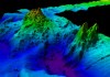
CSIRO has released results of RV Investigator bathymetry work to map the seafloor south of Tasmania.
Search results for "csiro"
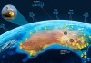
CSIRO launches AquaWatch water quality mission
Data from EO satellites will be merged with ground-based sensors to monitor and forecast water quality.

Applications open for CSIRO space mentoring program
The ‘Innovate to Grow: Space’ program will support 20 to 25 SMEs with mentoring from leading space experts.

CSIRO opens NovaSAR-1 tasking to researchers
Australian researchers can now apply to direct the synthetic aperture radar satellite’s advanced imaging program.

CSIRO moves to free model with Open Access
CSIRO said the changes would see the removal of paywalls and enable unrestricted access to its research.
CSIRO illuminates ‘bright spots’ in coastal ecosystem restoration
Strategy to vastly expand coastal ecosystem restoration for widespread benefits.
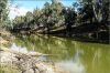
SmartSat CRC, CSIRO partner on waterway monitoring
Project to build sensor and satellite network to monitor river health.

CSIRO maps grain belt paddock boundaries from space
CSIRO’s ePaddocks contains paddock boundary information in an AI-derived dataset.

CSIRO, Microsoft partner on AI-driven imagery analysis
Microsoft AI platforms will power a raft of new CSIRO research projects.

CSIRO is mapping the underground
New real-time underground 3D mapping technology can be used to locate, steer and navigate.


