


A federally funded program will see short courses provided by universities in Queensland and New South Wales.
Search results for "BIM"

New inspection tech combines BIM and eye-gaze data
The technology has the potential to revolutionise the building industry and prevent multiple defects.
The crossover of mapping, BIM and GIS
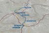
Brisbane’s new underground Cross River Rail is setting new benchmarks for the federation of BIM, GIS and 3D.
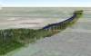
BIM to build a digital railway from scratch
Digital Rail Baltica is on its way, with 870km of tracks and 400+ bridges and other structures.

Efficiency is key in current BIM trends
On the heels of Bentley’s YII, we lift the lid on some of the current BIM trends, their drivers and projected trajectories.
SSSI YP BIM Webinar Series: Part 2
When:
25 July, 2019 @ 12:00 pm – 1:00 pm
Where:
Webinar
This month in the second instalment of our BIM webinars, we will be hearing from Professor Sisi Zlatanova of UNSW Built Environment about 3D mapping of the real world, the growing number of applications that[…]

August Position mag to have 3D & BIM focus
The packed August/September issue of Position is just around the corner.

HoloLens 2 powers next generation of BIM tools
Microsoft’s new HoloLens 2 appears poised to deliver on the promise of mixed reality for BIM.
MelBIM 2019
When:
21 February, 2019 @ 5:15 pm – 6:15 pm
Where:
RMIT, Building 80 (Swanston Academic Building), 445 Swanston St, Melbourne, VIC
The MelBIM February event will be hosted at RMIT Swanston Academic Building (SAB), 445 Swanston St, Lecture Theatre 80.07.01 – Level 7. Arrival is from 5:15PM with presentations commencing at 5:45PM. Attendance is free, drinks and food[…]

WGIC, buildingSMART sign MOU on BIM standards, location data
The MOU aims to drive uptake of BIM standards in concert with location-based technologies.


