


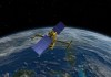
NASA and CNES will jointly conduct a survey of Earth’s surface water and ocean surface height.
Search results for "CNES"
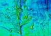
Bathymetry, remote sensing probe deep ocean
The voyage aboard the RV Investigator surveyed 20,000 square kilometres to a depth of 4,000 metres.
The low Earth orbit revolution
Low Earth orbit satellite observations are accelerating society’s journey towards sustainability.
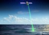
Bass Strait’s role in SWOT satellite mission
Australia’s Integrated Marine Observing System is using GNSS-equipped buoys to help measure ocean topography.
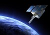
Environment-monitoring instrument reaches orbit
Argos-4 takes its place in the system that captures, processes and distributes environmental data.

Q&A with Anthony Murfett
A detailed interview with Anthony Murfett, deputy head of the Australian Space Agency.

Sea level rise redefines Queensland’s coast
New erosion prone areas declared for Queensland’s coast are defined by climate change factors.

International mapping community help Nepal
Members of the international mapping community have been assisting recovery operations in Nepal.

European Satellite Navigation Competition
The 2015 ESN Competition is looking to award innovative applications of satellite navigation.

Two new Galileo satellites successfully launched
The EU’s Galileo satellite navigation system now has eight satellites in orbit.


