


The 4S project will build a cloud-based, automated Earth observation service to map and monitor seafloor habitats.
Search results for "EOMAP"
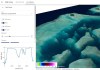
Satellite-derived bathymetry tool
EOMAP’s SDB-Online is a cloud-based web application for creating high-resolution, shallow-water bathymetric grids.
Best of the blogs
Spatial Source’s fortnightly round-up of the best in cartography, spatial analysis and creative applications of GIS.

Global water quality monitoring tool open to public
Decision support tool provides open access to global water quality data at a range of scales and resolutions.

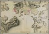
Mapping the Coral Sea reefs by satellite
A researcher in Cairns has completed detailed 3D depth maps of Australia’s Coral Sea reefs.

MapInfo Pro goes 64 bit
MapInfo Pro 64 bit simplifies map production and analysis of important geographic data.

Maps to monitor Australian waters
EOMAP and Landgate have teamed up to offer water-quality monitoring tools for Australian waters.

Great Barrier Reef mapped in 3D
The Great Barrier Reef has been mapped in unprecedented bathymetric detail using satellites.


