


The working group aims to create frameworks to make privately owned ocean science data publicly available.
Search results for "UNESCO"

EC, UNESCO renew marine spatial planning efforts
The European Commission and UNESCO are renewing their joint efforts to advance marine spatial planning.

Geospatial training for women in agriculture
More than 100 women recently trained in geospatial technologies at a three-day event in Costa Rica.
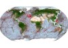
Global seafloor success: 25% has now been mapped
The addition of 5.4 million square km of new data means that 24.9% of the Earth’s seabed has now been mapped.

New Zealand joins global Seabed 2030 project
The project aims to compile all bathymetric data into a freely available map of the entire ocean floor.

Virtual history: project recreates shipwrecks in 3D
Curtin research project to render historic Australian shipwrecks like never before.

Australia’s dangerous fantasy: diverting population growth to the regions
A century of Australian history shows it won’t work.

Revealed: 2015 discovery located Spanish galleon with $22bn cargo
The ‘holy grail’ of shipwrecks has been the subject of false discovery claims previously.

Global water quality monitoring tool open to public
Decision support tool provides open access to global water quality data at a range of scales and resolutions.

Australian scanning tech to help solve Dutch shipwreck mysteries
Wrecks of the Batavia and other 18th century merchant ships sought with new 3D scanning technology.


