


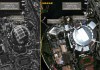
DigitalGlobe has announced the industry-first availability of 30 cm satellite imagery products.
Search results for "worldview-3"

First WorldView-3 images released
DigitalGlobe has released the first 40cm images from its new WorldView-3 imaging satellite.

WorldView-3 successfully launched
DigitalGlobe’s WorldView-3 EO satellite has successfully launched from Vandenberg Air Force Base.

DigitalGlobe’s WorldView-3 nears testing phase
Ball Aerospace has completed integration of DigitalGlobe’s WorldView-3 satellite.

Worldview-3 satellite announced
Walter Scott, the founder and chief technical officer of DigitalGlobe has used the 28th Annual National Space Symposium in Colorado Springs to announce the go-ahead of his company's WorldView-3 spacecraft. According to a set of specifications released for the new spacecraft, it will carry pan, multi-spectral and short-wave infra-red (SWIR) sensors, with a […]
Maxar, Umbra sign SAR access agreement
Maxar customers will have dedicated access to Umbra SAR data, with resolution down to 13 cm.
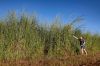
Mapping invasive grasses with machine learning
Researchers have developed a model that can identify Gamba grass with up to 90 percent accuracy.

Australian Defence signs $100 million deal for high-res satellite imagery
DigitalGlobe chosen to help deliver on the pledge to invest in satellite imagery.

Tackling illegal fishing from satellite
One third of fish is illegally sourced. CSIRO’s new tool will identify offenders before they reach shore.

Best of the Blogs – 16 May 2017
Self-healing maps Vs Where is North Korea? – Best of the Blogs time!


