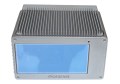
High-end camera and optical specialists, Phase One Industrial, have announced full integration of its iXU and iXU-RS aerial cameras with DJI’s M600 and M600 professional class drones. Built using DJI’s SDK, this is the latest drone platform supported by Phase One Industrial for aerial surveying applications.
The aerial cameras’ integration with DJI’s M600 and M600 Pro platforms is already delivering high quality solutions for aerial imaging applications.
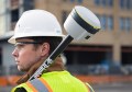
“Using the Phase One Industrial IXU camera with the new Integration package for our DJI M600 drone, the results were extraordinary,” said UAV Flight Systems Manager Tobias Wentzler, Lufthansa Aerial Services. “We achieved millimeter per pixel accuracy, allowing us to inspect the required objects in exquisite detail and lift our mission results and accuracy to a new, high-end level, identifying the subtlest cracks or imperfections that were not visible to conventional inspection methods.”
Phase One Industrial iXU and iXU-RS aerial cameras’ integration with DJI M600 and M600 Pro drone systems include:
- 100MP and 50MP metric aerial cameras;
- Smart triggering of the camera by waypoints / fixed distance / fixed time;
- Support for mission planning applications (such as DJI Ground Station pro) – for waypoints missions;
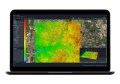
- Geo-tagging of all files’ location and gimbal position;
- Dual remote controllers (drone and camera) enable each operator (UAV pilot and camera operator) to focus on their respective mission goals;
- Industrial-grade build of the camera and aerial lenses, all of which are designed specifically for tough use in harsh environments.
The integration also provides a new iX Capture Mobile app for iOS, featuring an intuitive, user-friendly interface, and support for total remote control of the camera.
iX Capture Mobile was designed using the DJI open platform development tools, and offers various operating modes, including:
- Video Streaming;
- Auto or Manual Capture settings to determine the values of the ISO, shutter speed and aperture;
- Auto capture mode to enable image capturing by waypoints, fix distance or by time intervals;
- Camera control via DJI Lightbridge 2 dials.
These industrial-grade cameras also offer direct integration with many other UAV manufacturers, such as Coptersystems, AerialTronics, Pulse Aero, and UMS Skeldar drone platforms, and support the workflows of many leading image post processing software, such as Pix4D, Agisoft, SimActive, and others.