


Phoebe Davis has begun a six-month internship with the Leica Geosystems’ GNSS team at the company’s HQ.
Search results for "leica"
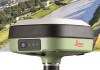
Leica’s GS05 smart antenna now in Australia
The GS05’s streamlined data-collection functionalities enable surveyors to do more each day in the field.
All-in-one surveying with the Leica Nova MS60
Leica Geosystem’s groundbreaking Multistation combines a robotic total station with 3D laser scanning.
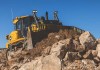
John Deere teams up with Leica Geosystems
The companies aim to boost the heavy construction sector through delivery of positioning and sensor tech.
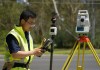
Leica’s AP20 AutoPole: A new angle on surveying
Leica Geosystem’s new AP20 AutoPole with tilt compensation is providing huge productivity improvements.
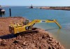
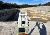
Leica Geosystems digs a dredging job out of a hole
When Ertech’s legacy machine control gear could no longer cut it, a solution from C.R. Kennedy saved the day.

New Leica Geosystems GS18 I: a sneak peek at visual positioning
Surveyors see unlimited uses for the new Leica GS18 I RTK rover with visual positioning technology Rock seawalls are certainly a regular fixture up and down the southeast Queensland coast, and the team at Orion Spatial Solutions know them especially well. They have climbed – and at times crawled – across a good number of […]

Leica announces new, expanded Cyclone offerings
Leica rolls out two new offerings in its Cyclone suite of reality capture software.

Leica launches pint-sized smart antenna, Zeno FLX100
Leica lobs a tiny, modular new GNSS antenna for field capture, AR and vGIS applications.

Leica overhauls total station range ahead of anniversary
Leica Geosystems has upgraded its full range of total stations in anticipation of a company milestone.
