

The two primary technologies for mapping are photogrammetry and lidar. While lidar mapping is the newer of the two, does it necessarily mean it is better? The complexity of lidar lies in all the ancillary technology required to create a viable output, whereas photogrammetry needs no additional technology remaining the simpler of the two. This […]
Search results for "lidar"
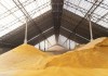
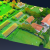
Bulk materials LiDAR scanning
Klau Geomatics’ Stockpiler bulk materials management system is for use in the handling of bulk dry products.
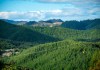
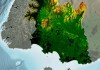
AI, LiDAR for remote forestry management
AI and 3D airborne LiDAR have been used to map radiata pine forests for most of New Zealand’s North Island.
LINZ begins 3D LiDAR mapping of NZ’s coastline
Woolpert NZ and NV5 Geospatial will conduct 3D LiDAR mapping of the North and South Islands, respectively.
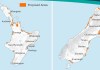
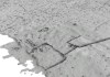
Four-year LiDAR mapping project completed
New Zealand’s Southland region is now LiDAR-mapped to 8m resolution in rural zones and 20cm in some urban areas.
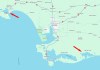
LINZ conducting aerial LiDAR survey near Invercargill
The campaign will produce detailed 3D maps of the seafloor and coastline between Riverton and Waituna Lagoon.
LiDAR shows Pacific cities are older than once thought
LiDAR has helped to show that city structures were being built 700 years earlier than previously thought.
Multispectral LiDAR
The IRIDESENSE 3D multispectral LiDAR sensor can analysing plant health and soil humidity levels remotely in real-time.

Real-time LiDAR mapping system
The Brumby LiDAR rapidly produces point clouds by removing the typically arduous post-processing workflow.
LiDAR leads to locating Roman roads
Data from the UK’s National LiDAR Programme has shown that not all Roman roads led to obvious destinations.
