

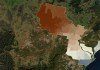
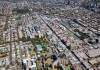
The winning UN World Data Forum entry explores datasets giving deep insight into heat vulnerability across NSW.
Search results for "qut"

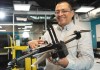
QUT researchers develop UAV collision detection
Researchers at QUT have developed a UAV with an on-board aircraft collision detection system.

QUT’s inaugural SIBA chair in spatial information
QUT has appointed Dr Tim Foresman as its inaugural SIBA Chair in Spatial Information.

Geospatial in School Awards recipients announced
Two outstanding teachers and a high school student have been recognised with prestigious awards.
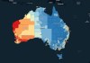
Cancer Atlas recognised with two awards
By applying spatial models to cancer data, the Atlas shows how diagnosis and treatment varies across Australia.
Kurloo: Building a global geospatial business
Kurloo is an Australian technology success story with its sights set on worldwide expansion.
Spatial Snippets for Wednesday, 4 December 2024
Check out our regular compilation of geospatial news snippets from across Australia and around the world.
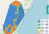
Mapping invasive plants using drone imagery
A QUT researcher has been awarded $240,000 to identify the best data collection protocols and AI models.
Supporting critical research with geospatial data
Geospatial research and analysis are critical in providing the evidence base required for policy and planning.
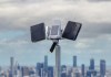
Soaring to new heights with the Kurloo Wing
Kurloo has introduced the ‘Kurloo Wing’ solar power system to enhance position monitoring performance.
