Handling large mapping projects, meeting deadlines and delivering high-quality results are typical challenges in photogrammetry. This is particularly true during peak season when multiple projects, often comprising tens of thousands of images, need to be processed in a timely manner.
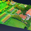
SimActive’s Correlator3D product is a high-end photogrammetry software package that enables users to deliver mapping products more quickly from drone, aircraft and satellite imagery. Powered by GPU technology and multi-core CPUs, Correlator3D™ performs aerial triangulation (AT) and produces dense digital surface models (DSM), digital terrain models (DTM), point clouds, orthomosaics and 3D models.

SimActive has recently released Version 9.0 of Correlator3D™ with distributed processing to boost power using multiple PCs. The new capability enables significant acceleration in speed by taking advantage of the computing resources available on the local network.
The new version automatically dispatches tasks to different PCs and enables dynamic adjustment of computing power during processing. Acceleration is virtually linear as a function of the number of PCs used, with no complex hardware setup required. As an example, two PCs lead to speed increases of up to 1.9X, three PCs 2.8X and five PCs 4.6X.
To learn more about the software, please visit: https://www.simactive.com/distributed-processing