

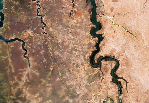
Resolution enhancement techniques can bring out the detail (right-hand half of this image) hidden in lower-resolution images (left-hand). Courtesy ESA/CC BY-SA 3.0 IGO.
Over the end-of-year period, we’ll be reprising some of the best of the articles we’ve published over the past 12 months. We hope you enjoy catching up on what was making news in 2021.
Agriculture’s use of satellite imaging and connectivity will add billions to the economy, according to a new AgriFutures report.
By Sarah Adams, Bob Furbank, Luigi Renzullo, Paul Tregoning and Martin Amidy
What was the last thing you ate? Where did it come from? How often do we reflect on the processes that create the food on our plate? Imagine a sandwich made of bread, butter, lettuce and chicken. Each mouthful is a mix of produce from Australia’s broadacre farms, dairy industry, horticulture and livestock industries.
Agriculture is a large and diverse sector. Farms cover 58% of Australia’s continental land mass and contribute over $65 billion to the Australian economy.
Agriculture, including farms, fisheries and forestry, has an ambition of becoming a $100 billion industry by 2030 — a goal set by the Australian National Farmers Federation.
That growth must happen within environmental constraints. This means increasing efficiency and productivity to make better use of the land currently available for agricultural production whilst minimising impacts on water resources and biodiversity. It’s a wicked problem.
Eyes in the sky
Orbiting above the Earth are pieces of the puzzle. Satellites are already making major improvements to agriculture through remote sensing, geolocation and increased connectivity.
For example, Earth and marine sensing adds an annual value of $37 billion to agriculture in the Asia-Pacific region. Historically limited by poor resolution, recent advances in machine learning, artificial intelligence and low-earth orbit satellites, are making satellite remote sensing a viable solution to an increasing number of agricultural challenges.
Satellite remote sensing lends itself well to the large-scale nature of Australia’s broadacre crops (such as wheat, barley and canola) and extensive livestock farms. Horticulture, dairy farms and other intensive plant and livestock industries tend to have a smaller land footprint, and often are better served by drones or UAVs.
Position, precision and producers
Australian farmers were world leaders in the application of GNSS for tractor auto-steer in the mid-1990s. However, uptake of geolocation technologies has been limited to areas with reliable internet and cellular mobile coverage, as connectivity is required for precise point positioning.
Farms with augmented positioning systems can steer tractors with the fine precision needed to keep them on defined wheel tracks. This stops machines compacting soil beyond the tracks, making it easier to cultivate and improving crop yield. Recent upgrades of the geodetic datum of Australia to GDA2020 have helped in this regard.
Fully autonomous vehicles are on the horizon, pending certain legal and regulatory frameworks, thanks to recent advances in robotics and machine vision. The planned Satellite Based Augmentation System (SBAS) is expected to deliver approximately 10-cm real-time positioning accuracy across all of Australia by 2025.
SwarmFarm, a business based in central Queensland, has developed an autonomous spraying platform that uses real-time kinetic (RTK) positioning and is controlled remotely via a tablet. It has an eight-metre spray boom with optical spot spray technology that identifies weeds and spot-sprays them, rather than covering the entire field… reducing herbicide inputs by up to 95%.
Remote sensing crops
Space-based remote sensing technologies are increasingly being used to quantify many components of the Earth system including vegetation types, land cover and land use, soil moisture, on-farm water storage and crop water use. There is significant scope to improve the management of agriculture and forestry by exploiting the available data from satellites. Next-generation sensor systems aboard miniature satellites will soon be able to provide alternative high-resolution data streams (spatial and temporal).
Visible light sensors are used to map crop distributions at a local and national scale. Infrared systems are used to monitoring biophysical parameters, such as vegetation moisture content and crop health.
The Normalised Difference Vegetation Index (NDVI), calculated from reflectances in the near-infrared and red part of the spectrum, is used in agronomy to identify areas in a paddock that show signs of stress. NDVI data can be collected by satellites but it is limited by low resolution and is more useful in large areas of pastures and crops rather than small-scale horticulture. There is scope for significant improvement in spatial and temporal resolution of this information if constellations of small-scale satellites are developed and launched.
Barry Haskins, Director and Agronomist at Ag Grow Agronomy in New South Wales, uses remote sensing provided through DataFarming as one of several tools to help his farming clients get the most from their land.
“Sometimes you can see areas that fertiliser or sowing has missed, before we go out on the farm for crop scouting. When we are dealing with very large-scale farms and paddocks, it is useful to see the area by satellite,” said Haskins. “It doesn’t save us time, but it allows us to be more targeted and more strategic.”
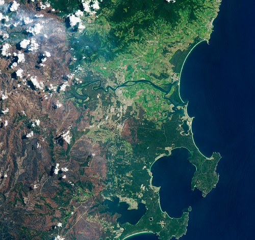
Floods in NSW, in the vicinity of Nowra and Jervis Bay. Courtesy USGS/NASA Landsat.
As well as crop scouting, Haskins uses satellite imagery to assist with precision agriculture — methods of making farming techniques more accurate through technology — for example by delivering different amounts of fertiliser across areas.
Haskins says the return on investment is highest in paddocks with more variability.
“In some paddocks we could increase yield by up to 20%, and for others we could get a cost saving of 15%. In this space, it is extremely dictated by the individual paddock.”
Emerging in this space is the application of machine learning and AI to multiple sensor outputs. These algorithms form the basis of crop and pasture biomass predictors. For example, wheat breeders across Australia plant more than a million field plots annually to compare the performance of varieties.
With increasing resolution of satellite images (down to 15 centimetres and below) and more frequent imaging, satellite data is becoming pivotal for crop breeding. The improved spatial resolution means that instead of using expensive manual measurements, crop performance can be compared daily using satellite-based imaging.
From the forest to the trees
Remote sensing assists with environmental monitoring. After the 2019–20 bushfires in New South Wales, data from Landsat satellites were used to map the extent of burned areas. Measuring colour change in vegetation before and after a fire provided a rapid way to support environmental management decisions and to understand impacts on forestry resources.
Indufor, a global forestry sector consulting firm with offices in Australia and New Zealand, uses satellite data for forest data validation and due diligence.
“When someone is selling a forest, we check the area to make sure it’s correct and ensure trees have not been lost due to fire or wind damage.” says Dr Pete Watt, Head of Indufor’s Resource Monitoring and Climate Change team.
“Sentinel-2, a landscape-level satellite that covers large areas pretty frequently (every 5 days) is fantastic for forestry. Because it is a really well-calibrated satellite, it is easy for us to process. We have a system that can cycle through multiple images and clear the cloud off it and identify changes.”
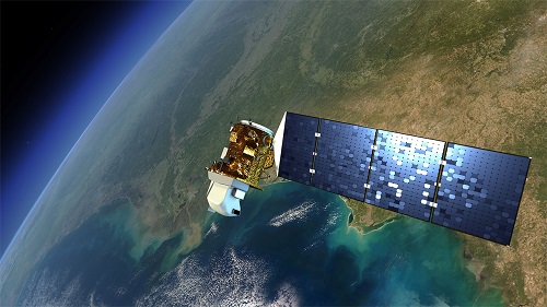
Landsat spacecraft have been collecting imagery of the Earth’s surface for over 50 years. Courtesy NASA.
Indufor uses Sentinel data to identify changes in forests. It splits the forest into discrete areas and measures the amount of forest cover in that area, then compares it to previous images to see how that area has changed over time. The areas that have changed are highlighted orange on the dashboard.
“If there has been a wind damage event, you can compare before and after images and see where the damage has occurred. That saves time,” says Watt.
SBAS for farms and forests
New space-based technologies and applications are expected to have a dramatic impact on the rural sector.
Key among them is the SBAS coming in 2025, which will improve GPS accuracy from a couple of metres down to around 10 centimetres. The SBAS economic report predicted it will bring an additional $2.2 billion of value for agriculture over 30 years.
SBAS is expected to unlock new applications such as virtual fences, which use GPS-enabled smart collars for cattle. Created by CSIRO and commercialised by agri-tech start-up Agersens, the eShepherd™ works by giving cows an audio cue as they approach the boundary of the virtual fence. If the cow continues, the collar delivers a small electric pulse that is less than the shock of an electric fence, but enough to act as a deterrent.
A recent trial of the eShepherd virtual fence on a beef cattle farm in New South Wales found it was effective at keeping livestock where the farmer wanted them within a field. Most cows responded to the audio cue alone.
One of the SBAS Test-bed Demonstrator Trials run by Central Queensland University showed that, in the case of dairy, enhanced pasture utilisation through virtual fencing could save producers up to $100 per cow per year — around $780 million for the entire Australian and New Zealand dairy sub-sector.
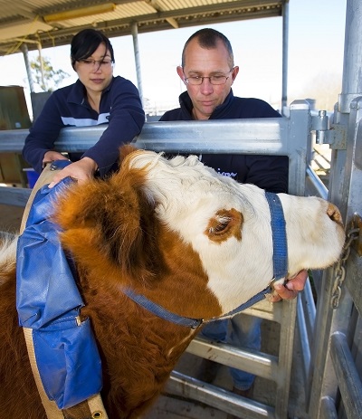
Virtual fencing systems use GPS satellites and collars on cattle, so that cattle hear a sound when they approach a ‘fence’ boundary. Courtesy CSIRO/David McClenaghan.
Tracking the location of individual sheep, by GPS-enabled collars or ear tags, could reduce predation. When threatened by predators, flocks of sheep tend to move in a circling pattern. Real time location tracking could send alerts to farmers when an attack is happening, perhaps in time to intervene. The SBAS economic trail estimated that the technology could save approximately 39 million adult sheep over a 30-year period.
In forestry, SBAS is expected improve the ability to manage hardwood native forests along riparian margins; the land near rivers. Riparian margins are protected through buffer zones to avoid adverse impacts on the environment. Forest owners often add a further buffer (known as buffer-on-buffer areas) to account for inaccuracies through GNSS. Higher spatial resolution through SBAS can reduce buffer-on-buffer areas and lead to improved yield.
Other benefits include geo-tagging of trees to protect culturally significant sites, and geo-referencing to reduce time spent mapping on site and associated health and safety incidents.
Barriers to adoption
While the number of satellite-enabled solutions available to Australian rural industries has increased with the emergence and rapid growth of agri-tech, wide scale adoption remains low. Satellites can have a greater impact on Australian agriculture if we can improve connectivity, make demonstrations more accessible, clarify the value proposition and simplify the way people can access data.
Adoption of research and development outcomes in the rural sector is multifaceted and complex. Some of the major barriers of adoption for space-based technologies identified in a recent AgriFutures report are as follows.
Lack of big data infrastructure. An avalanche of data presents problems for researchers and agronomists alike. Gigabytes of imaging data can be acquired every few minutes from different satellites. The volume is of the scale seen with the Square Kilometre Array, where petabytes of images are discarded after an initial filtering. What is required is not only a data repository but virtual laboratories and dashboards where data can be downloaded by GPS location.
Lack of connectivity. Connectivity is an enabling technology. Without it, primary producers cannot access the data they need to make decisions and run operations. Australia’s wide-open spaces and vast marine estate represent a significant challenge to connectivity. Satellite connectivity helps to fill the gaps, but is expensive and does not always meet requirements. This is expected to change in the next five to ten years as new low-earth orbit mega-constellations of satellites are launched.
Unclear return on investment. While reports have identified the return on investment of adopting satellite-based technologies, these studies have been at an industry or macro level rather than an enterprise level. Producers are using information from these technologies to make decisions that could return (or cost) hundreds of thousands of dollars. They need to know the information is reliable.
One solution is to validate the technology at scale and demonstrate them in practice. For example, demonstration sites are an effective tool to show the technology working under on-farm conditions.
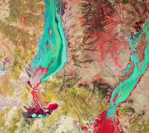
Sentinel-2 image of the Channel Country, a pastoral region in Queensland. The image was processed to include near-infrared, which makes vegetation appear bright red. Courtesy ESA/CC BY-SA 3.0 IGO.
Lack of integration. The lack of interoperability between services and platforms has created complexity and duplication. There has been an explosion of new offerings in the market, but generally they do not integrate with each other. An absence of industry data standards and data systems architecture is an ongoing impediment.
Not meeting needs. A growing agri-tech ecosystem in Australia is bringing new ideas and products to the rural sector. Agile start-ups can rapidly bring new products to market, however the need to monetise quickly can mean products are released before they are refined.
Producers are looking for solutions that are turn-key and deliver value out of the box, and are generally reluctant to invest in products that feel undeveloped.
Need for consultation. Best practice for creating new products or services is ensuring that they meet a real need for potential customers. This means market research, workshopping, consulting, prototyping, testing and trialling with primary producers.
Consultation fatigue has been identified as an emerging issue for producers. This is a challenging issue, as industry feels that solutions are not fit for purpose, but it also doesn’t have time to engage with the businesses making new products to define their needs and refine solutions.
One way to address this issue is to collaborate with farming systems groups, consultants, advisors, suppliers and value chain partners, state primary industry departments, CSIRO, Research and Development Corporations (RDCs) and universities.
These organisations have deep knowledge of the industry and experience working with producers, and can help to bridge that gap. There is a growing market for intermediary services like these. Just as producers require assistance to navigate the crowded technology market, tech companies need assistance to navigate networks in the rural sector.
Need for new skills. To implement new technologies, often people must develop new skills. Large enterprises can hire staff with that skillset and spread the cost of training over a larger production base. This makes engagement with new technologies cost-effective and viable.
In smaller enterprises, taking time to re-skill and the associated opportunity cost does not always justify adopting the technology. They might find it more cost-effective to use contracting services, for which there is a growing market.
Need for local support. Historically, local dealers or suppliers have provided farmers with on-farm support. The move to city-based or virtual support services is a loss keenly felt by primary producers. Strong social networks in rural communities mean technology adoption is often driven at a local level. Companies can benefit by developing indirect pathways to market and on-selling relationships with local service providers who can offer valued in-person support.
Vision for the future
The uptake of information from satellite-based geospatial data can help agriculture reach lofty goals, providing food security for a growing global population, strengthening regional economies and increasing export potentials.
There is a wealth of interesting challenges in agriculture for geospatial researchers looking to make a difference, for example:
How can we be confident that data is accurate, and communicate that confidence? To develop products suitable for on-farm application, it is essential that space-based imaging data is ground-truthed to ensure it is appropriate for Australian conditions. Without calibration for local conditions, and confidence from farmers that data are accurate, products are of limited use and will continue to be under-utilised.
How can we create systems that talk to each other? Creating a set of industry data standards and data system architecture could address the currently fragmented landscape. A framework for data sharing between systems could create value that is greater than the sum of its parts.
Where can we transfer technology from other industries into the rural sector? There are many geospatial solutions already operating in other industries that could be adapted for agriculture. Collaboration with consultants and RDCs would be a positive step to connecting the dots.
As one of the largest industries in Australia, and facing increasing pressure from a changing climate, agriculture has a lot on its plate. The growth in the agri-tech and commercial space sectors is making satellite data more accessible than ever, making this a rich area to explore. Next time you sit down for a meal, think about where your food came from and whether your work could make a difference.
The full AgriFutures report, Space-based technology — opportunities for the rural sector, can be found at https://www.agrifutures.com.au/product/space-based-technologies-opportunities-for-the-rural-sector/.
Sarah Adams and Martin Amidy are with the Centre for Entrepreneurial Agri-Technology (ceat.org.au); Bob Furbank, Luigi Renzullo, Paul Tregoning are with the Australian National University.
This article was first published in Issue 114 (Aug/Sep 2021) of Position magazine.
Stay up to date by getting stories like this delivered to your inbox.
Sign up to receive our free weekly Spatial Source newsletter.


