Bentley Systems has announced new asset analytics capabilities that leverage Imagery Insights from the Google Maps Platform to rapidly detect and analyse roadway conditions.
Unveiled at Google Cloud Next 2025, the new capabilities in Bentley’s Blyncsy product offering — which applies AI to crowdsourced imagery for automated roadway asset detection and inspection — will help infrastructure professionals improve roadway maintenance and support disaster recovery.
Bentley and Google announced a strategic partnership in October 2024 to integrate Google’s geospatial content with Bentley’s infrastructure engineering software.
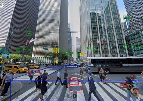
The combination of Google Street View, Vertex AI and Blyncsy will enhance the ability of departments of transportation, and the engineering firms and consultants supporting them, to identify areas of concern and analyse changes in the condition of roadway and transportation assets over time.
The addition of Google Street View’s global panoramic imagery enables Bentley to provide highly detailed analysis of assets along with visual references, while Google’s Vertex AI adds the ability to build and maintain models to alert transportation agencies of changes to infrastructure assets before they become safety hazards.
In addition to supporting roadway maintenance activities, these capabilities can also aid in disaster recovery efforts, providing a cost-effective solution for conducting rapid damage assessments, which can help affected communities rebuild faster.