

Map shows 5.9 million US property owners unaware of flood risk
 Geoawesomeness
If you are a US citizen, you may want to recheck your home’s flood risk. A new national-level study has found that a total of 14.6 million properties across the United States are at risk of severe flooding. Of this, 5.9 million property owners are either not aware of or underestimating the risk they face because federal maps do not identify them as being within the Special Flood Hazard Areas (SFHA).
America’s Failed Response to Covid-19
Maps mania
The New Statesman has published a series of interactive maps which dramatically visualizes just how bad the United States has been in responding to Covid-19. The maps show areas in the United States and in European countries where there are 50 cases or more of Covid-19 in a week per 100,000 residents.
All new Map Dots!
 The Map Kiwi
All new minimalist map designs of New Zealand cities.
The Impact of NOAA’s Height Modernisation Program
 The Map Room
Last month the New York Times covered a subject that you’d expect to be too technical for the general reader: NOAA’s efforts to recalibrate elevation data as part of its update to the National Spatial Reference System, expected in 2022 or 2023.
Sea Level Rise-Coming to a City Near You
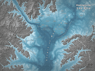 Map of the week
Conspiracy of Cartographers has a series of maps showing what will be underwater in various cities after 215 feet (66 metres) of sea level rise. Keep in mind that this is “end point” sea level rise and not anything we would see in our lifetimes.
Stay up to date by getting stories like this delivered to your mailbox.
Sign up to receive our free weekly Spatial Source newsletter.


