Services like MetroMap 2D Web App and MetroMap 3D simplify the decision-making process for a broad spectrum of industries, from individual traders to large companies and government departments. The mixture of high-resolution aerial imagery and spatially precise data on demand makes the MetroMap platform a problem-solver and time saver.
The addition of the MetroMap 3D Store takes the platform forwards into the position of industry disrupter, simplifying the purchase of 3D models for architecture, engineering, construction, and various other industries.
MetroMap, and parent company Aerometrex, are pushing ahead with solutions-based GIS.
GIS BENEFITTING NON-GIS USERS
The MetroMap web app represents a move towards accessible GIS. Any MetroMap user can benefit from the platform’s stringent spatial accuracy through its simple toolset, regardless of any knowledge or previous experience with GIS. The platform works for multiple levels: from those wanting high-resolution aerial imagery for a range of business decision making to GIS users who need spatial context to the high-resolution images.
On the surface, drawing a line or polygon on MetroMap and getting a measurement seems simple, but getting that measurement accurate to within centimetres requires stringent GIS expertise. Therein lies the democratising of GIS – users benefit from spatial accuracy through the simple tool and process outputs. A landscaper may never know how their polygons drawn on MetroMap are made accurately, but they will notice when materials ordered based on those measurements are correct. A solar company will benefit from the precise modelling of sunshine on a rooftop without knowing the back end process that ensures the data is accurate. Still, their clients will notice the high-efficiency their systems get.
COMPRESSING DISTANCE
High-resolution aerial imagery can reduce the frequency of, or altogether remove the need for, on-site inspections for many businesses. Reduced travel has evident business efficiency and profitability outcomes, and the current pandemic environment has caused a re-think of necessary travel and interactions.
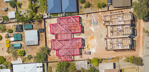
A roofer no longer needs to inspect a house to determine a roof’s surface area and the materials required to cover it. MetroMap’s polygon tool and Roof Pitch data, through the building footprint layer, will give the required information to quote without leaving the office. They can also see other potential complications that could affect the job; solar panels, tree overhang, or site access issues.
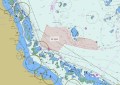
Planning, construction, and road/traffic businesses carry out inspections and measurement of an area in a web browser without needing to interact with the active intersection. They measure lines and complex polygons within the system, and can upload their own GeoJSON, KML, KMZ and Shapefiles.
FREQUENT CAPTURES FOR CHANGE MONITORING
Historical data adds another insightful element to the MetroMap platform. Aerometrex captures and processes capital cities multiple times per year and regional centres regularly. Users get multiple captures in some areas, stretching as far back as the 1940s with the oldest Sydney imagery.
Businesses and individuals use historical data to analyse change over time. Users place imagery side-by-side with a swipe tool, so they can see what changes between dates.
Solar energy companies monitor changes in solar panel penetration within given territories for opportunity prospecting. They can also analyse the size, number, and placement of panels to better understand customer preferences for their sales and consultations. Local Governments can see how their constituent area changes throughout the years. MetroMap simplifies change tracking over time.
RAPID CAPTURE FOR RAPID DECISION MAKING
Aerometrex runs a rapid capture service that adds imagery to MetroMap quickly for clients, and optional shared intellectual property arrangements will mean those images are hosted on the public MetroMap platform. Clients are delivered the imagery through the same MetroMap platform accessed by all users.
An insurance company requested Aerometrex’s rapid orthoimagery capture service in Queensland, which was processed and added to MetroMap following tropical storms. Their staff then used MetroMap to assess storm damage to houses quickly and accurately. The imagery is detailed enough to see individual damage spots on roofs, or smashed solar panels requiring replacement. That data expedited insurance claims during a period of high requests.
Rapid captures are made over bushfire affected areas too. Within days, a plane can capture thousands of square kilometres, and the Aerometrex processing team can have the imagery ready for government and private industry to assess large areas on MetroMap. Again, that aerial data makes large scale assessment faster so the response can be sooner.
EASY 3D
MetroMap recently launched a “clip, zip, ship” service for buying 3D data via the MetroMap Store. Users select custom areas of Australian capital cities in OBJ, FBX, SLPK, and Cesium 3D Tile formats and have their model emailed directly. It represents another disruptive move to the 3D model buying process, giving users the ultimate power of what and how they buy. Other datasets derived from both imagery and LIDAR are planned for adding into the 3D Store in future.
Architects and engineers have been the earliest adopters, immediately grasping how the system benefits their workflow. They no longer need to invest in complete city models. Instead, they buy what they need as they need it, from individual buildings to multiple square kilometres. The power is truly in the buyer’s hands.
LEARN MORE ABOUT METROMAP
Go to metromap.com.au to learn more about the platform and start a 7-day free trial
Go to metromap.com.au/store to learn more about the 3D Store
Information provided by Aerometrex.