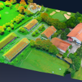
CSIRO scientists have invented a new 3D mapping technology, Zebedee, giving researchers and the public unprecedented access to sites of global significance. It is licensed to UK start-up company GeoSLAM and global distributor 3D Laser Mapping.
The Zebedee system consists of a lightweight laser scanner mounted on a simple spring mechanism. It bobs around as the operator moves through the area under investigation, converting 2D measurements into 3D fields of view.
It's thought to be the world's first truly mobile, hand-held, rapid laser mapping system.
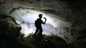
CSIRO researchers used the new 3D mapping technology to explore the Koonalda Cave in South Australia, near the western border, for the SA Museum.
The delicate site in the Nullarbor Regional Reserve, closed to the public, was used as a flint mine by Aboriginal people between about 30,000 and 10,000 years ago.
They left strange markings, called finger flutings, in the soft limestone walls by dragging their hands along established grooves.
Archaeologist Dr Keryn Walshe from the SA Museum said she wants to work out who made the finger flutings – men, women or children – but they are so fragile they crumble at the slightest touch.
"It is really tempting; it is really hard, actually, not to touch this soft surface because it's so inviting," she said.
"It's this beautiful pure white colour, it's like snow. It looks so lovely and soft you just want to touch it to see what it's like, but you mustn't."
Now researchers can analyse the 3D model from the comfort of their laboratory in Adelaide, using computer software or physical reconstructions of the cave created using 3D printers.
"It's a fantastic research tool, the fact that we can use the models in the lab when we have really good light and good conditions to work under, whereas in the cave, because it's in complete darkness, it's really hard to do the research," Dr Walshe said.