

The first Earth observation images from South Australia’s Kanyini satellite, have been released more than 200 days after the spacecraft went into orbit.
Kanyini was deployed into low Earth orbit from SpaceX’s Transporter-11 mission last August and has since been closely monitored by the mission control team at Inovor Technologies in Adelaide.
The team has been working through commissioning of the satellite’s systems, confirming that the solar panels and batteries are functional and X-band radio communications are operational.
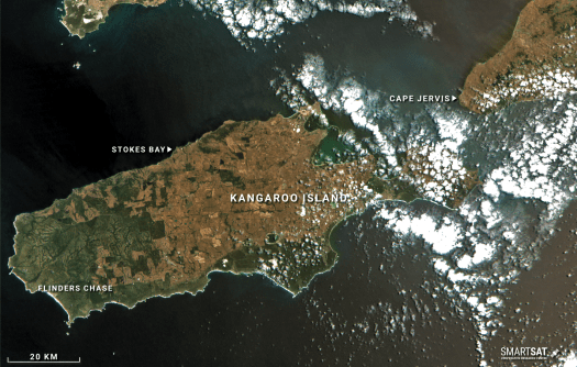
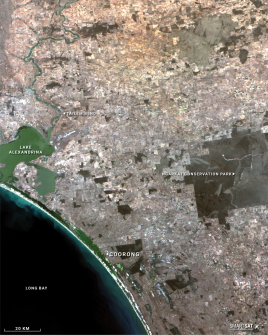
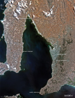
The preliminary images were collected during Kanyini’s on-orbit commissioning phase, and include high-resolution views of Kangaroo Island, the Yorke Peninsula and Adelaide.
The images reveal infrared details that can be used to monitor crop health, vegetation density and changes in inland and coastal water conditions.
The Kanyini mission is Australia’s first state-owned satellite and is a joint initiative between the South Australian Government, SmartSat CRC, Inovor Technologies and Myriota.
“The release of Kanyini’s first images is an exciting moment for the mission team and the South Australian space community, reinforcing our position as a national leader in space technology,” said the South Australia Minister for Defence and Space Industries, Stephen Mullighan.
“The commissioning of the satellite’s ongoing operations will ensure Kanyini can deliver critical real-world benefits once fully operational.”
Kanyini’s HyperScout 2 hyperspectral imager is a three-in-one instrument that combines hyperspectral and thermal imaging with high-level data processing and AI capabilities.
The satellite also features an IoT payload developed and manufactured in South Australia by Myriota, which enables the capture of both imagery and IoT data — such as groundwater levels and pipeline condition — from a single satellite.
Professor Andy Koronios, SmartSat CRC Chief Executive Officer, added that “These first images are the result of years of hard work and dedication from our talented team of engineers as they work through the onboard commissioning of the spacecraft”.
“SmartSat is proud to be funding a suite of projects in artificial intelligence, onboard processing and machine learning aimed at using the data gathered by Kanyini to address challenges in agriculture, water management and the environment.”
Inovor Technologies Chief Executive Officer, Dr Matt Tetlow, pointed out that “This achievement reinforces Australia’s growing sovereign capability in space technology. We look forward to further calibration and data collection in the coming months.”


