

 Maps Mania
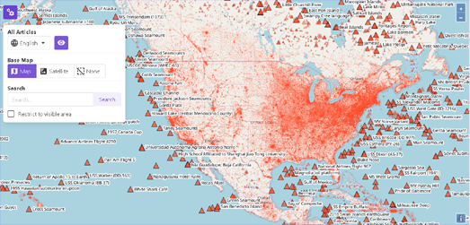
Once upon a time Google Maps had a Wikipedia layer. Using this Wikipedia layer you could discover all the places around you which had an article on Wikipedia. This Google Maps layer was a fantastic way to learn about all the interesting, historical points of interest around your location. It was definitely one of the most useful functions on Google Maps. So Google got rid of it. Luckily there are a few other interactive maps which can help you learn more about the world around you using information posted to Wikipedia.
How Google Maps is helping users to avoid coronavirus hotspots
 Geoawesomeness
With the coronavirus pandemic continuing to spread in many countries as economic activity revives, Google has ramped up its efforts to help people stay safe when they’re out and about. The next time you fire up the latest version of Google Maps on your smartphone, you will receive an option to activate COVID-19 data on the map.
 GeoHipster
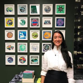
Jennifer Maravillas is a Brooklyn based visual artist. She creates portraits of our land in media ranging from found paper to watercolor. Her aim in this work is to capture universalities and connections across disparate communities by studying social structures from histories, landscapes, and visual design.
Charles Booth’s London Poverty Maps Online
 The Map Room
Last year I told you about Charles Booth’s London Poverty Maps, a book collecting and analyzing the maps produced by Booth’s block-by-block survey of poverty and the social classes of late 19th-century London. Somehow I missed the fact that there has been an online, interactive version of said maps for several years now.
 Map of the week
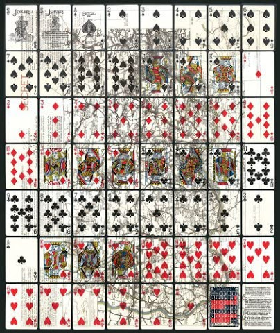
In World War II, the United States Playing Card Company designed cards for POW’s in Germany with maps hidden between the paper layers. When soaked in water the cards could be peeled apart and prisoners could see secret escape routes.
Stay up to date by getting stories like this delivered to your mailbox.
Sign up to receive our free weekly Spatial Source newsletter.


