

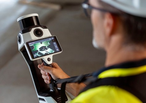
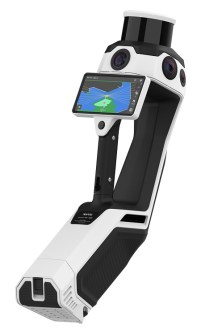
The NavVis MLX lightweight, ergonomic instrument is a significant advance in the field of reality data capture.
PARTNER FEATURE
The construction industry is on the cusp of a digital revolution, with advancements in innovative technologies transforming the way projects are executed. Labour shortages, time delays and costly rework provide ongoing challenges for site managers… but one newly released solution, the NavVis MLX, is positioned to significantly transform workflows.
Aptella, the authorised distributor for NavVis in Australia, New Zealand and Southeast Asia, has introduced the MLX, the newest dynamic, handheld laser scanner to the construction market. A significant advancement in the field of reality capture, this lightweight, ergonomic solution sets a new standard for exceptional quality, efficiency and portability in data capture.
Overcoming limitations in handheld scanning
Traditionally, handheld laser scanners have suffered from limitations such as low-quality data, tedious operation and unreliability. These limitations often lead to compromises in accuracy and efficiency, and the quality of work.
The newly released NavVis MLX addresses these challenges head-on. It boasts a 32-layer LiDAR sensor, capturing high-resolution panoramic images and delivering exceptional point clouds, providing precise digital representations of even the most intricate building elements. The unique design ensures optimal LiDAR positioning for superior data capture, while the comfortable harness system enables extended scanning sessions and detailed environmental capture. Additionally, the MLX’s lightweight and compact design makes it easy to transport and deploy, significantly speeding up workflows for AEC and surveying professionals.
Beyond traditional scanning: The NavVis advantage
Beyond its traditional handheld scanner capabilities, the NavVis MLX creates 360-degree panoramic images, unlocking valuable data for diverse applications and project stakeholders.
“In the reality capture world where precision and efficiency are paramount, the NavVis MLX represents a groundbreaking leap forward,” says Geoffrey Preece, Market Development Manager for the Geospatial industry at Aptella. “As we navigate the future of construction, embracing this cutting-edge technology will not only redefine reality capture but also allow our customers to set new standards for excellence in their industries.”
A seamless ecosystem for enhanced workflows
The NavVis MLX seamlessly integrates with the existing NavVis ecosystem. It can operate independently or in tandem with the NavVis VLX wearable scanner, offering a versatile and accessible solution for indoor and outdoor environments. Back in the office, captured data from both devices works flawlessly with NavVis IVION software, creating a robust digital twin foundation for enhanced collaboration and informed decision-making.
Investing in the future of construction
Aptella is committed to providing construction and surveying professionals with cutting-edge technology that streamlines workflows and improves project outcomes. The NavVis MLX is a significant leap forward in handheld reality capture, offering unparalleled versatility and productivity when it comes to data capture.
For more information, visit aptella.com/product/navvis-mlx.


