

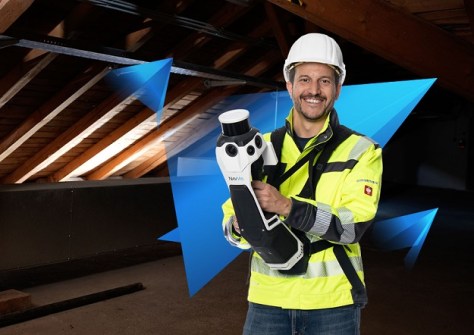
NavVis has announced the launch of its MLX instrument, a SLAM-based handheld laser scanner which, it says, greatly improves data quality, portability and user comfort.
“With NavVis MLX, we aim to address the critical need for high-quality data in portable laser scanning solutions for key industries such as AEC, surveying, and reality capture,” said Felix Reinshagen, Co-founder and CEO of NavVis.
“Our customers have emphasised the need for a professional, affordable tool that can scan in narrow, hard-to-reach places that complements NavVis VLX. A device that is easy to carry, perfect for scanning in these confined spaces, and ready for broader deployment within their crews, without sacrificing NavVis’s renowned usability and data quality — and that’s NavVis MLX.
“Overcoming this engineering challenge was no small feat, and I am incredibly proud of what we have achieved.”
NavVis says the MLX delivers high-quality point cloud data captured by a 32-layer LiDAR sensor and 270- and 360-degree panoramic images. The company says the MLX’s design optimally positions the LiDAR for better data capture, in combination with a harness system that allows for comfortable extended use.
“Form follows function, and the function of a reality capture tool is to deliver excellent data. The form of NavVis MLX has been meticulously designed for this purpose,” says NavVis CTO & Co-founder Georg Schroth.
“Most of the time, NavVis MLX is in a stationary position, so you don’t have to carry it constantly. When needed, it can be easily taken out and moved freely.
“And with the ability to create 360-degree panoramic images even when held in front of your body, its data is extremely valuable for various use cases and project partners,” he added.
NavVis says the MLX is designed to work both independently or alongside the NavVis VLX in the field as a flexible and accessible solution both indoors and outdoors.


