

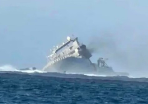
The Royal New Zealand Navy’s hydrographic survey ship, HMNZS Manawanui, has capsized and sunk after running aground on a reef off the coast of Samoa.
Fortunately, all crew members and passengers were rescued and are safe.
“We are very grateful for the assistance of everyone involved, from RCCNZ who coordinated rescue efforts, to the vessels which responded and took our crew and passengers from Manawanui to safety,” Maritime Component Commander Commodore Shane Arndell said.
The accident happened on Saturday evening, 5 October, while the vessel was conducting a hydrographic survey just one nautical mile from shore.
According to the Royal New Zealand Navy (RNZN), at 6.40am on Sunday the ship was listing heavily and smoke was visible. By 9.00am it was known to have capsized and was below the surface.
The vessel is in water about 30 metres deep, and the area has been declared a prohibited area by Samoan officials.
A light sheen of oil is being dispersed by wind and waves, according to Commodore Arndell. Maritime NZ responders are working with Samoan authorities, NZDF personnel and wildlife experts from Massey University to plan the environmental response.
The 85-metre-long, 5,741-tonne HMNZS Manawanui was commissioned by the RNZN in 2019, having been purchased second-hand for NZ$100 million from a Norwegian oil and gas company, which had operated it for the prior 15 years.
Manawanui replaced the RNZN’s dedicated hydrographic survey ship, HMNZS Resolution, which was decommissioned in 2012.
Manawanui was equipped with a Kongsberg K-POS Dynamic Positioning 2 System, a Kongsberg EM712 Multi Beam Echo Sounder and a EA 440 Single Beam Echo Sounder.
In addition to its hydrographic survey capabilities, the multi-purpose Manawanui was also equipped for diving support, disaster relief, search and rescue and explosives disposal.
The ship had been on its third deployment to the South-West Pacific this year, and had a series of activities scheduled in the Kermadec Islands, Samoa, Tokelau and Niue.


