The Australian Transport Safety Bureau has concluded its investigation into the crash of a helicopter conducting a geophysical survey.
On 3 September 2011, the pilot and one crewman of a Robinson Helicopter Company R44 helicopter, registered VH-HCA (HCA), departed an airstrip located near Kumarina roadhouse, approximately 150 km south of Newman, Western Australia.
The task to be conducted was consistent with previous flights in that it required the pilot to land at regularly spaced waypoints (nodes) that were located about every 2.5 km along a predetermined flight path. This meant that the pilot was required to take off and land the helicopter about every 2 to 3 minutes until the planned task was complete. During that morning the pilot had successfully completed about 80 takeoffs and landings.
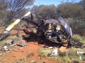
The crew was conducting low-level geophysical survey operations when the pilot was observed to have slumped forward in the seat.
The crewman, who was seated behind the pilot, made unsuccessful attempts to rouse the pilot. The helicopter subsequently impacted terrain causing significant injuries to the crewman and pilot. After the impact the pilot regained consciousness but later succumbed to his injuries prior to the arrival of medical assistance.
The investigation found that, following the pilot’s probable incapacitation during flight, the helicopter’s descent could not be arrested before impacting terrain. It was likely that the incapacitation was of a similar nature to other previous unconsciousness events reportedly experienced by the pilot while not flying.
The crewman sustained serious injuries that required medical intervention, but survived the accident.