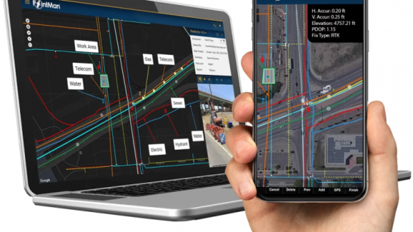
Pix4D and ProStar have announced that they are joining forces to supply a subsurface asset mapping solution to support the utilities sector.
The collaboration will combine Pix4D’s 3D modelling capabilities with ProStar’s PointMan to deliver a mobile solution that enables construction, engineering and utility professionals to visualise and manage buried infrastructure.
PointMan’s mobile and cloud-based architecture is designed to precisely capture and map subsurface assets, while Pix4D’s software transforms this data into real-time 3D mapping.
This combination will enable users to view a representation of what lies beneath the Earth’s surface, in 3D, using a smartphone.
“The ProStar-Pix4D partnership is more than a product integration — it is a milestone in the evolution of infrastructure management, offering a next-generation solution that redefines how buried assets are recorded, visualised and managed,” said Page Tucker, Founder and CEO of ProStar.