

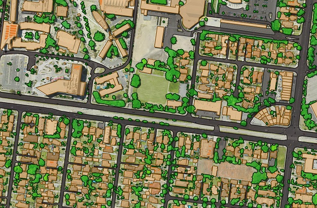
Visualisations of buildings, trees and surface cover data extracted from Aerometrex aerial imagery using GeoX AI technology. Courtesy Geoscape Australia.
Geoscape Australia has announced a partnership with Israeli artificial intelligence firm, GeoX, to employ machine vision and deep learning technology to enhance Geoscape’s 3D digital maps of Australia.
“By applying GeoX’s patented AI technology to the highest quality aerial imagery, we will significantly evolve our digital model of Australia,” said the CEO of Geoscape Australia, Dean Capobianco.
The company says more accurate digital models of Australia’s urban environment will enable the data-driven foundation of Digital Twin applications.
Examples of the kinds of benefits the up-to-date data will bring include:
- Improving the assessment of risk for insurers
- Enabling architects to visualise new developments in the context of their surroundings
- Helping noise modellers better understand where noise impact will be felt
- Powering the modelling of energy use patterns in commercial and residential buildings.
“Advanced information about the built environment, on a national scale, can drive efficiency, cost reduction, insight and revenue generation across many sectors of the economy, including insurance, property development, energy and telecommunications,” said Capobianco.
Co-founder and CEO of GeoX, Izik Lavy, said Geoscape’s creation of the digital Australia is one of the most extensive and advanced projects in the world in terms of in-depth mapping of a country’s buildings.
“Our machine vision and deep learning technology opens a new generation of accuracy and richness of built environment data, providing a leap forward for Geoscape compared to the technologies used so far,” Lavy said.
“By leveraging our tech and Geoscape’s continuous data processing capability, every organisation in Australia could access reliable and advanced property data.”
Geoscape has mapped all buildings and land cover across Australia using satellite imagery. It also accesses high resolution aerial imagery from Aerometrex’s image library.
“We’ll re-map more than 10 million buildings using GeoX’s AI tech, which will include most urban buildings in Australia. We’ll also recapture and enhance all remaining buildings across the country,” Capobianco said.
Geoscape will include location data derived using GeoX’s AI technology in its Geoscape Buildings and Surface Cover data products from October 2021.
Stay up to date by getting stories like this delivered to your inbox.
Sign up to receive our free weekly Spatial Source newsletter.


