vGIS Augmented Reality platform seamlessly brings together GIS, BIM and reality mesh data
Perth-based MNG Survey have long recognised the power of augmented reality. With a history of embracing new tech, the firm got in early – and they went big.
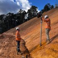
For more than 5 years their clients have been able to step into their in-house ‘holoverse’, or hologram room, where clients could explore realistic 3D models.
Now the firm is using powerful AR technology to take this experience into the field after recognising a need for better data recording and presentation in subsurface locating. The team chose the new vGIS AR platform, which they have paired with Leica’s range of high accuracy GIS antennas.
These tools have combined to make the invisible visible – helping their clients cut down on asset strikes and make key design decisions more easily.
The vGIS platform combines GIS, BIM and reality mesh in one seamless offering.
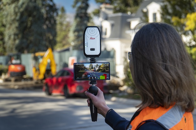
“With the hologram room – it’s fantastic, but you had to come to the office and the model was in the room,” says Dale Keighley, technology specialist with MNG. “With vGIS’ AR technology, you can head out with your iPhone, iPad, or Microsoft HoloLens, and review your 3D model on site – its portable. AR is a great way to visualise intelligent spatial data sources in situ, and vGIS does it well.”
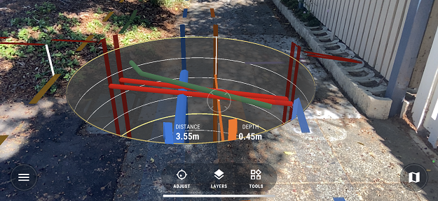
The vGIS platform combines client-provided GIS data with third-party data from a range of sources to create real time and in the field holographic visuals. vGIS works with traditional GIS data, 3D building models, geological data, LiDAR scans, custom maps, and more – resulting in a seamless, immersive experience.
“The vGIS platform enables even a non-domain experts to see and understand complex utility assets that often are invisible in the real world,” says Maurice Borer of vGIS and Leica distributor CR Kennedy. “It does a great job of bringing the underground utilities clearly to the surface by superimposing the digital assets into the camera view of an off-the-shelf device, meaning the user can easily visualise where those assets are.”

Paired with the Leica Nano FLX100, vGIS delivers survey-grade AR capabilities in portable, reliable, and affordable packages.
And with the ability to do on-the-fly reality capture, MNG’s Dale Keighley says vGIS almost lets you turn back time.
“Let’s say you have an excavated pipe, and you can basically walk around and take a short video or stills of the open pit,” he says. “Now you’ve done your reality capture, and you upload it and long after the pit is covered up, you can have a reality model capture that you can refer back to,” he says.
“With vGIS you can basically put that pipe back into the scene where you’re standing, so that you can see again just where that pipe was really exposed,” he says.
Group Manager, Business Development, Rob Kiernan of MNG says his team sees firsthand that asset strikes continue to be a big problem for municipalities, utility providers and builders alike. He says the combination of the vGIS platform and accurate positioning is a game-changer.
“Some of the engineering houses and utility providers were looking for a way to see the assets more clearly, especially in complex situations when you have a lot of utilities below the ground and crossing over each other,” he says. “So, the augmented reality with vGIS has given us that next level of visibility of where are you at risk of striking things.”
vGIS lets users see the hidden and future infrastructure around them.
In addition to helping to cut down on costly asset strikes, a recent study identified a 10% productivity boost for utility locators using advanced visualisation tools like augmented reality.
The vGIS system also features a patent-pending calibration process that allows high-precision locational and lateral accuracy to be established within seconds.
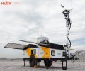
The MNG team have been trialling the system with a Leica GG04 plus smart antenna, which they originally acquired for its combination of ease of use and centimetre-level accuracy.
“It’s a bonus that the GG04 could tie in and link directly with the vGIS software,” says MNG’s Dale Keighley.
In fact, the vGIS platform is designed to work seamlessly with the full line of Leica’s positioning hardware, including the just released pint-sized Zeno FLX100.
“For us, the FLX100 is a god-send,” says CR Kenney’s Maurice Borer. “It is economical and immensely portable, just the size of two cigarette packs, and with the brackets users can attach it easily to a mobile device.”
“So it is the perfect partner to vGIS for users who want to have this precision, either handheld or with a pole, and to have the confidence to know, yes, this is exactly where this asset is.”
Due to the combination of ease of use and rich 3D visualisation, the team at MNG Survey have found that the vGIS platform has also been a great design tool, allowing architects and engineers not only to see the hidden assets lurking underground, but to envisioning what could be there as well.
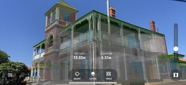
“This AR platform also has definite benefits above ground as well,” says Rob Kiernan of MNG. “For example, we’ve used laser systems to survey a historic building here in Western Australia that is up for refurbishing, and we now have the ability to add in a digital model of a new building alongside it in order to see how it interacts.”
“That is where augmented reality really starts to come into its own,” he says.
He says the vGIS system is especially key because it so smoothly combines GIS, BIM and reality mesh data and displays them so clearly, that all users across a project are able to actually see and understand what 2D maps and plans can’t so easily reveal.
The vGIS augmented reality system is available in Australia through CR Kennedy. For more information on vGIS or Leica’s line of complementary smart antennas, reach out to the team at CR Kennedy at +61 3 9823 1533 or on crksales@crkennedy.com.au.
Information provided by CR Kennedy.