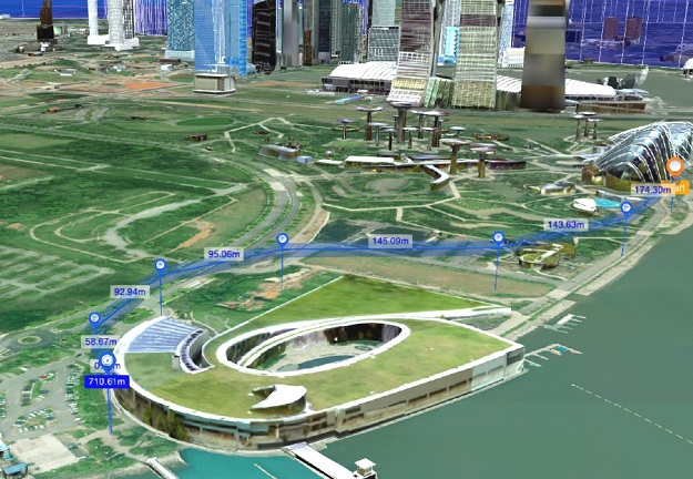
A OneMap3D visualisation of drone flight path planning and a no-fly zone. Courtesy SLA.
Singapore’s new official national 3D map, OneMap3D, has been launched by the Minister for Culture, Community and Youth and Second Minister for Law, Mr Edwin Tong SC.
Developed by the Singapore Land Authority (SLA), the 2D format of OneMap was first launched in 2010.
In 2017, an enhanced version was rolled out with an expansion of location-based information and navigational services including real time traffic data, as well as APIs for application developers.
Building on this foundation, SLA’s geospatial team began exploring new capabilities on using open-source 3D geospatial technology and 3D city modelling for the conversion of OneMap from 2D format to 3D.
OneMap3D serves as a dynamic visualisation platform, presenting an immersive experience of a user’s surroundings.
“The development of OneMap3D marks an important milestone in Singapore’s geospatial journey,” said Minister Tong.
“It is built on our commitment to enhance our country’s geospatial capabilities and to provide new geospatial solutions for businesses, government, and the wider public.”
To further industry use and the development of geospatial technology through OneMap, SLA has also signed three separate memoranda of understanding with Ninja Van, Kabam and PropNex.
The MOUs will foster collaborative ties and knowledge sharing between SLA and the three key industry players to leverage on geospatial data to support smart services and solutions.
The MOU with Ninja Van Singapore will pave the way for collaborative efforts on geospatial co-innovations to improve hyperlocal and granular data at street level for last mile delivery.
The Kabam MOU will see the trial of automated data capture with robots, reducing the time and effort from manual data capture. This partnership will also enable SLA and Kabam to establish standards for robotics-ready maps and the interoperability of map information for compatibility across multiple platforms.
In the real estate space, the MOU with PropNex will bring about the development of new feature data collection and customised API to enhance PropNex’s applications and OneMap geospatial information.
“The MOUs are part of SLA’s efforts to collaborate with industry leaders to promote growth and opportunities through geospatial solutions,” said SLA Chief Executive, Colin Low.
“We seek to foster closer collaboration between government and industry to drive competency and create value-added services through geospatial innovation.
“SLA will continue to explore a range of options and methods to capture data effectively and efficiently, to provide a robust map base and mapping datasets as a driver for smart nation solutions.”
Stay up to date by getting stories like this delivered to your inbox.
Sign up to receive our free weekly Spatial Source newsletter.


