

A representation of an open data set, courtesy Thomas Shafee (CC BY 4.0).
Spatial data is at or near the top of the lists of information produced and requested by Australian businesses, governments and academia, according to the Digital Transformation Agency’s Observatory Team.
The Observatory Team analysed requests for open data sets from 750 different community members and compiled statistics on the type of data being sought and which types of users were seeking it.
Business users made the most number of requests at 31%, followed by the spatial community at 12%, the environmental sector at 10% and health at 9%.
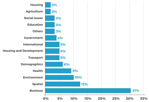
Percentages of the community who use open data. Courtesy DTA Observatory Team.
Looking at the types of data requested according to the type of user, the Observatory found that:
- For business users, spatial data requests made up 12.5% of the total, behind business data (22.1%) but ahead of environmental data (7.7%)
- For government users, spatial data came out on top at 23.6%, ahead of demographics (10.9%) and the environment (10.9%)
- For academia, spatial data (9.7%) came third after the environment (19.3%) and health (14.5%)
According to the Observatory, Australia’s three largest contributors of open data sets are the CSIRO, Geoscience Australia and the Australian Antarctic Division. It also found that state and territory governments are the biggest open data publishers at an aggregate level.
Interestingly, local councils were found to make up the largest group of manual publishers of data on the data.gov.au website.
The Observatory also found that a “common attribute among many successful data publishers is that they have a scientific focus,” and that “scientific organisations tend to have formal data publishing standards and a culture that encourages its staff to build on existing knowledge”.
Finally, it was found that the most prolific open data publishers take advantage of automated systems, such as the Making Australian Government Data Available (MAGDA) system.
MAGDA automatically searches the internet for open data and creates a page for that data on the data.gov.au portal. About 94% of the open data currently on data.gov.au has been absorbed by MAGDA.


