

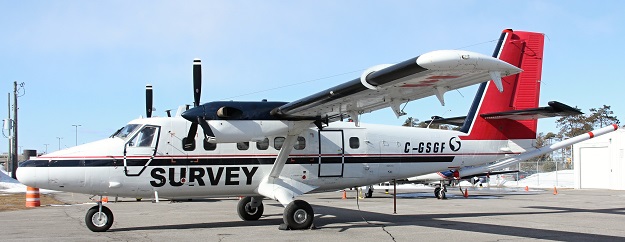
Sander Geophysics’ DHC-6 Twin Otter is fitted with an Airborne Inertially Referenced Gravimeter that measures one-part-in-a-million changes in the Earth’s gravitational pull.
Airborne gravity surveys are enhancing the national vertical reference system and support advances in positioning.
By Alex Woods and Anna Riddell
Gravity is one of the fundamental forces in the universe. It keeps our planet in a comfortable orbit around the Sun, holds down our atmosphere and, of course, keeps our feet on the ground. Gravity is essential to life on Earth.
However, the force of gravity isn’t the same everywhere on Earth. The strength of gravity varies depending on distance from the Earth’s centre of mass and the density of nearby rocks. By observing and modelling the variations in gravity, we can discover new information about the Earth and open up exciting opportunities for innovation such as through enhanced Global Navigation Satellite System (GNSS) positioning capabilities and applications.
Historical use of gravity data
Historically, gravity data have been collected for geological mapping applications. National and state geoscience agencies have been gathering gravity data for many decades to improve our understanding of the Earth’s geological ‘architecture’ and how it has evolved over time. The data reveals the hidden density contrasts in the rocks beneath our feet, which helps with the management of mineral resources.
Gravity data have also been used in the derivation of national gravity-based geoid models that play a major role behind the scenes in GNSS positioning technology by enabling instant access to ‘real world’ heights. In this regard, surveying and spatial applications have benefited substantially from the existing catalogue of gravity data captured for geoscience projects.
AUSGeoid models
Readers may be familiar with the AUSGeoid models that are used within GNSS technology to convert ellipsoidal heights to Australian Height Datum (AHD) heights. The most recent AUSGeoid2020 model was developed to complement the Geocentric Datum of Australia (GDA2020).
This model was created from two distinct components; namely a gravimetric component and a geometric component. The Australian Gravimetric Quasi-Geoid (AGQG) model is the gravimetric component, and it is made from the national database of terrestrial gravity data and satellite gravity data. An additional geometric component is added to the AGQG model, to force the AUSGeoid2020 model to closely approximate AHD as defined by the survey control mark network.
GNSS positioning technology depends on these gravity-based geoid models to provide meaningful height information aligned to a national vertical reference system. AHD and the AUSGeoid models are known to have a number of biases and distortions which mean stand-alone GNSS positioning is only capable of deriving AHD heights with an accuracy of around 13 centimetres across Australia.
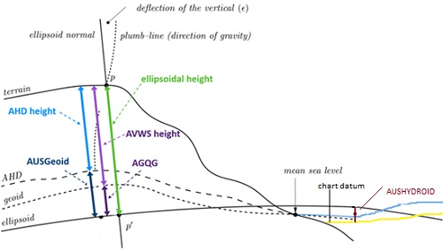
Elevation layers, showing the AUSGeoid, AHD and AVWS models.
The Intergovernmental Committee on Surveying and Mapping (ICSM) has introduced the new Australian Vertical Working Surface (AVWS) based on the AGQG model, which has a vertical accuracy of 4 to 8 centimetres across Australia. Further improvement of the AGQG model accuracy (<3 centimetres) to enhance the accuracy of heights from GNSS positioning technology has driven the need for targeted airborne gravity surveys as described in this article.
Targeted airborne gravity surveys for GNSS positioning
Throughout 2022 an airborne gravity survey is being performed across southeast Victoria. Recognising the multiple applications and benefits of the gravity data, the project has been collaboratively organised by Surveyor-General Victoria (SGV), Geological Survey of Victoria (GSV) and Geoscience Australia.
Victoria already has good coverage of ground sourced gravity data and GSV has organised targeted airborne gravity surveys over the Gippsland and Otway Basins and around Bendigo for geological applications. However, there are regions along the coast, offshore and in the high country that are difficult to access and have poor gravity data coverage. This leads to increased uncertainty in the AGQG model, reducing the accuracy and reliability of heights from GNSS positioning across these areas.
This is of particular concern in coastal and populated regions (such as Melbourne) where there are higher expectations and requirements for accurate GNSS derived heights.

An airborne gravity survey is being performed across southeast Victoria throughout 2022.
What does an airborne gravity survey involve?
Put simply, the airborne gravity survey across southeast Victoria is designed to improve the data coverage in these regions. The survey is being performed by Sander Geophysics, a group that specialises in airborne geophysical surveys.
Two fixed-wing aircraft are being used for the survey — a DHC-6 Twin Otter and a Cessna Grand Caravan. The aircraft are fitted with an Airborne Inertially Referenced Gravimeter (AIRGrav) that measures extremely small changes (one part in a million) in the Earth’s natural gravitational pull.
To capture the required density of data, the aircraft fly along a planned route with flight lines spaced 500 metres to 1 kilometre apart. To ensure the accuracy of the gravity measurements, the aircraft will fly relatively low in public airspace at a nominated ground clearance of 150 metres, increasing to 300 metres over built-up areas.
The survey will collect consistent and evenly distributed gravity measurements over the central Victorian coast, Melbourne and eastern Victoria.
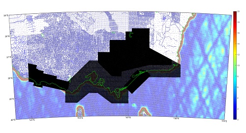
Gravity data collected within the airborne gravity survey area.
Australian Vertical Working Surface
The new airborne gravity data will improve the AGQG model, which is the basis of the new Australian Vertical Working Surface (AVWS). It will optimise the performance of and support GNSS positioning with 5-centimetre vertical accuracy anywhere in Victoria.
The AVWS has been made available as part of the Australian Geospatial Reference System (AGRS) modernisation program and is directly linked to GDA2020. The AVWS is offered as an alternative vertical reference system to the more-than 50-year-old AHD, which contains known distortions and biases. The advantage of the AVWS is that it is instantly accessible, anywhere using GNSS and the AGQG model, and does not rely on the ageing survey control mark network.
In addition, AVWS heights have a much clearer understanding of vertical uncertainty and are available seamlessly on- and offshore. This makes the AVWS more suited for hydrographic applications and inclusion in the development of the AUSHYDROID.
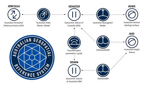
Components of the Australian Geospatial Reference System.
Gravity surveys and modern vertical reference systems
Targeted airborne gravity surveys to support modernised vertical reference systems have been performed in several other countries. For example, a nation-wide airborne gravity survey was conducted across New Zealand to create NZGeoid2016, which is the basis of the New Zealand Vertical Datum 2016 (NZVD2016). This national vertical reference system has been embraced as it replaced the multiple different height surfaces previously used across the country and has the obvious benefit of being instantly accessible within GNSS positioning.
Similarly, in the United States of America a national airborne gravity survey has led the Gravity for the Redefinition of the American Vertical Datum (GRAV-D) project.
The airborne gravity survey in Victoria is the first targeted Australian survey designed to enhance the AGQG model and optimise the AVWS. This survey has been organised in tandem with another airborne gravity survey around the greater Adelaide region, funded through AuScope. Similar airborne gravity surveys are also being planned for NSW, and proposed for Queensland, South Australia and Tasmania.
The development and implementation of modernised vertical reference systems based on national gravity-based geoid models recognises the significant benefits in supporting GNSS positioning and facilitating the consistent and seamless exchange of vertical spatial information.
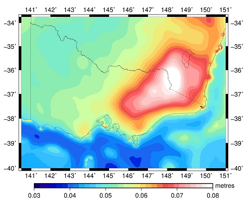
Map of the Victorian geoid uncertainty.
Benefiting from enhanced GNSS heights
As indicated, the new gravity data are required to enhance the AGQG model and optimise the performance of the AVWS. Implementation of the AVWS and the broader AGRS modernisation program is designed to operate seamlessly with GNSS technology and support the ongoing advances and innovations in GNSS positioning.
Geoscience Australia is the national focal point for positioning coordination and is part of a global network delivering positioning capability through a network of ground station infrastructure and satellite technology. Through its Positioning Australia program, Geoscience Australia provides accurate, reliable and real-time positioning data across Australia and its maritime zones.
Positioning Australia improves positioning accuracy from 5 to 10 metres to 3 to 5 centimetres in areas with mobile phone and internet coverage, with 10 centimetres everywhere else. To capitalise on these advances in GNSS positioning technology, it is important that the AGQG model and subsequent AVWS heights are as accurate and reliable as possible.
GNSS positioning is becoming more accessible and this is encouraging innovation in existing and emerging applications, many of which require accurate height information. Advances in GNSS positioning are improving how spatial information is created, as well as how business and the community interact with spatial information.
For example, airborne LiDAR surveys depend on GNSS positioning and geoid models to create digital elevation models that are an essential component in the creation of Digital Twins. Similarly, modern surveying practices use GNSS and the geoid model to measure heights to support construction and development activities, particularly those related to the management of water and the environment.
A wide range of applications (e.g. construction, planning, agriculture, transport, emergency services) will be enhanced through improved GNSS heights and interaction with the more accurate elevation models and mapping products.
Alex Woods is Geodesy Manager at Surveyor-General Victoria, Department of Environment, Land, Water and Planning. Dr Anna Riddell is Assistant Director, National Geodesy Section at Geoscience Australia.
This article was first published in the Apr/May 2022 issue of Position magazine.
Stay up to date by getting stories like this delivered to your inbox.
Sign up to receive our free weekly Spatial Source newsletter.


