Caroni was born because of the potential of SLAM technology and how it adds value to different stakeholders and industries. We offer immediate solutions through combining easy capture and advanced processing and analysis software.
As part of our offering, we are now an authorised dealer for GeoSLAM solutions. GeoSLAM is a market leader in 3D geospatial technology solutions, and its unique “go-anywhere” technology is adaptable to all environments including indoor, outdoor, underground or difficult to access spaces, providing accurate 3D mapping without the need for GPS. GeoSLAM was founded in 2012 as a joint venture between CSIRO and UK company 3D Laser Mapping.
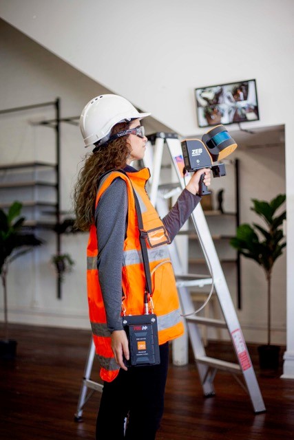
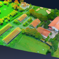
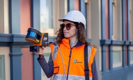
We want to introduce you to the ZEB Horizon, GeoSLAM’s strongest ever SLAM. Quick and easy to use, it enables you to capture, view and understand the world around you!
ZEB Horizon
Effortless Data Capture
- Great for indoor and outdoor use, including spaces where features are positioned further apart.
- Lightweight and rugged, simple to use, fast to capture and easy to process giving you the most accurate information you need to make the most important decisions.
- 300,000 points per second with an accuracy of 1-3cm*.
Ultimate Flexibility in One Device.
One ZEB Horizon, unlimited ways to use it. Move within accessories in minutes.
Take your ZEB Horizon to the skies with the UAV mount!
- Capture from new heights with improved relative accuracy without the need for an IMU, even in areas with no GPS.
- By mounting the ZEB Horizon to a UAV, it can be used for airborne applications with a range of 100m and payload of 3.7kg.
And to the road with the car mount!
- Car mounted data collection for urban road layouts, features and signage.
- Speed up any outdoor project that could be captured handheld.
 The future of integration is here! Combine LiDAR with High Resolution imagery with the ZEB Discovery
- LiDAR and high-resolution imagery for rapid urban mapping.
- The strongest SLAM algorithm on the market, now available with ultra-high definition imagery.
- Brand new features with the ZEB Discovery:
- Clip and go technology, take your ZEB Horizon from walking to UAV and now the ZEB Discovery in minutes.
- Automated workflow for pointcloud and imagery synchronisation.
- GPS for location.
And you can also connect your point cloud to the world with the ZEB Locate
- ZEB Horizon + backpack frame + GPS antenna
- For use in any application where georeferenced point clouds are needed.
- Track, manage and maintain assets with ZEB Locate.
- It supports any GPS receiver that can log NMEA GGA and GST data or get CSV DA1 like file , which you should purchase separately.
Anyone with a ZEB Horizon can buy the accessories to create the ZEB Discovery or ZEB Locate. Pick and choose accessories to suit your applications.
Summarising the advantages of the system, Carlos Gonzalez, founder of Caroni, said “the ZEB Horizon allows you to reduce the data acquisition time because its ease of use and portability, besides, its versatility allows you to cover different environments and many applications with an accuracy that fits most geospatial jobs. For instance, you will be able to scan the interior, facades and roof of a warehouse with only one system, and process and register the different scans in only one software suite, thus reducing time on site and also during processing”.
To find out more about GeoSLAM or the ZEB Horizon, contact the team at Caroni via info@caroni.com.au or at +61 8 6189 8709 or visit www.caroni.com.au
*accuracy is environment dependent
Information provided by Caroni.