

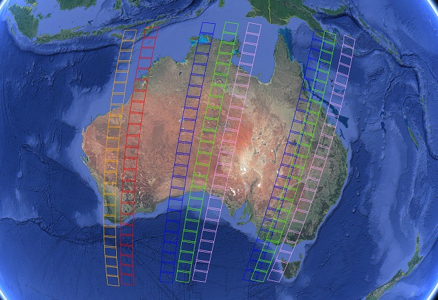
Swaths where the orbits of Landsat 8 and Landsat 9 would overlap above Australia if the underfly occurred during 12 to 16 November. Courtesy Geoscience Australia.
A once-per-mission overlap of the orbits of Landsat 8 and the newly launched Landsat 9 will provide a chance to compare important data.
Landsat 8 has been in orbit since 2013, while Landsat 9 was launched on 27 September 2021.
For a short time in November, Landsat 9 will be in a lower-altitude orbit compared to its older sibling, and this means that there will be brief periods when Landsat 9 flies underneath Landsat 8.
The ‘underfly’ period will occur over a 5-day period in November or December with partial overlaps of the swaths either side of the third day, which will have 100% coverage.
During this period, scientists will have the chance to compare observations made by both satellites, thereby contributing to the calibration and validation of Landsat 9’s instruments.
Once Landsat 9’s orbit is slowly raised to its final altitude (the same as Landsat 8’s), this orbital overlap opportunity will not occur again.
The US Geological Survey, which operates the satellites, is keen for Earth-bound scientists to help with the calibration effort by conducting ground measurements in areas where the swaths overlap.
Such measurements must be able to be converted to reflectance values, with full range hyperspectral (~350 nm to ~2,500 nm) observations being preferred.
According to Geoscience Australia’s Mark Broomhall, “Drone-based hyperspectral spectrometer or hyperspectral camera data (VIS or VIS-NIR) would be of great value as well. Aquatic reflectance or remote sensing reflectance would also be of value.”
“Coincident measurements with CIMEL, Microtops or atmospheric parameters of interest for atmospheric correction would also be appreciated.”
Anyone interested in contributing should contact Geoscience Australia via earth.observation@ga.gov.au.
Stay up to date by getting stories like this delivered to your inbox.
Sign up to receive our free weekly Spatial Source newsletter.


