Global geospatial IT solutions provider to the Telco and Utility industries, we-do-IT, recently announced the launch of its mobile GIS solution, LatLonGO.
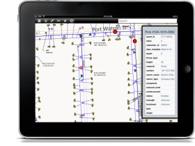
LatLonGO distributes GIS information to mobile devices, including iPad, Android and Windows 8 tablets. It compresses and packages the data for mobile tablet devices, allowing them to work offline without network access, important in remote areas. To ensure broad compatibility, it can load data from a variety of GIS formats.
“Our vision is to provide geospatial data from any GIS vendor on any server platform to any device at any time using a very simple interface with no or little training requirements – just like the apps we all know and love on our tablets and smart phones,” explained Dr. Walter Hesse, Managing Director, we-do-IT. “Current mobile GIS offerings lack in ease-of-use, off-line capability and cross-platform smart device support.”
LatLonGO is for field crews who require access to their organisation’s GIS data, even in the field where no communication networks exist. It provides an up-to-date electronic copy of corporate GIS data on a standalone off-line or ‘sometimes connected’ device.