In this webinar from 3 March 2022, Bentley Systems launches the most complete Survey and Site Design Solution ever offered to the ANZ market.
If you work in GIS, road design, town planning, urban design, site surveying, site development and related fields, then this webinar is for you.
Bentley Systems’ new solution lets you identify site constraints early, understand financial implications and produce plans you are proud to offer.
The webinar and Q&A outline how to use the solution for a typical site design workflow, incorporating all the most important stages:
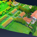
- Terrain creation and analysis
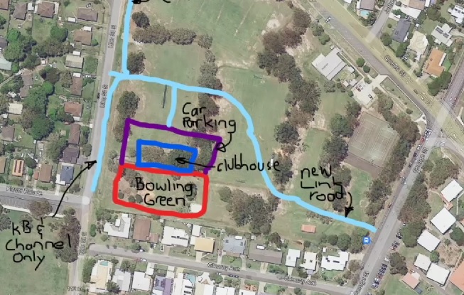
- Urban road widening design
- Carpark and recreational area design
- Drainage and utility design and analysis
- Plan production and digital model delivery
- Model visualisation
You’ll also hear from aerial data acquisition experts from Air Inspect Australia, who share insights and learnings from using the new solution in their daily work:
- Dave Body, Senior Industry Strategy Manager, Design Engineering, Bentley Systems. Dave has spent decades in the road, rail and mining sectors as a civil designer, surveyor, engineer and business development manager. He has held several roles within Bentley Systems, and prior to that worked for GEOPAK Corporation and a local government in Western Australia.
- Sean Mattheisz, Chief Remote Pilot and Business Development Manager, Air Inspect Australia. Having started his career in robotics and then gaining more than 20 years’ hands-on experience the IT and services industry, Sean turned his technical skills to unmanned aircraft. At Air Inspect Australia he delivers cutting-edge aerial strategies and innovative campaigns that increase efficiency and safety, accelerate growth and maximise the budgets of commercial enterprises.
- Ty Tamblyn, Senior Remote Pilot, Air Inspect Australia. Ty has been involved in the drone industry since 2016, when he made the leap from being a professional photographer to being a specialist in aerial data acquisition. Ty has worked on many successful campaigns that have enabled clients to use aerial data to solve commercial property problems.